Enhancing crop mapping and modeling capabilities
23 April 2015
With ever-growing demand for food in the Middle East and North Africa region and declining water availability, decision-makers need to find ways to balance the consumption of natural resources. They need to understand the different crop production areas and the management systems used, including the contribution of irrigation. Yet, up-to-date data on crop or irrigation maps or models to simulate the varieties and management systems exists in very few countries.
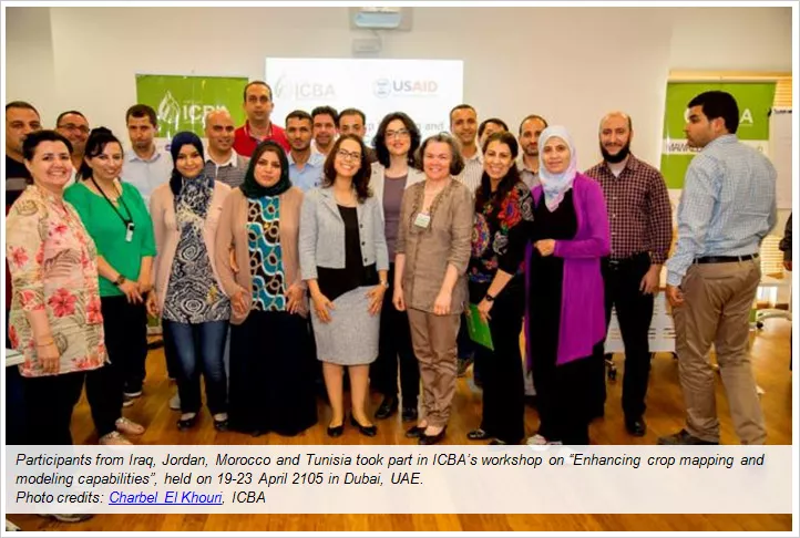
ICBA, in collaboration with the USAID, organized a workshop on 'Enhancing crop mapping and modeling capabilities' on 19-23 April 2015 at its headquarters in Dubai, the United Arab Emirates. Participants from Iraq, Jordan, Morocco, and Tunisia attended the workshop.
“This course helped in filling these knowledge gaps by taking participants through the practical steps to generate new data. It aimed at enhancing the skills in using satellite imagery for crop mapping and crop modeling using DSSAT for exploring management and climate change impacts on agricultural production systems,” said Mr. Rashyd Zaaboul, Climate Modeling Scientist at ICBA.
Rashyd was one of the five instructors from ICBA, including Dr. Rachael McDonnell, leader of the MAWRED program at ICBA, Dr. Adla Khalaf, remote sensing scientist, Mr. Karim Bergaoui, climate and water modeling scientist, and Dr. Makram Belhaj Fraj, agronomy scientist.
The five-day workshop focused on understanding satellite imagery, sources, downloading and pre-processing. In addition, it focused on developing field data collection exercises to support crop mapping from satellite images. Also, participants were given an introduction on image classification combining satellite imagery and field data to derive crop maps and to assess the accuracy of the resulting crop maps.
Participants learned about the DSSAT and its use in crop management and food security planning under climate today and in the future. They prepared daily atmospheric data from global data sets to input to DSSAT and assessed variation in crop production using simulation model.
What participants say
The workshop was really good; the offered subjects tackled various current issues and provided various options for solving the climate change impact.
Issa Farhan Al Abra, Jordan
The training was excellent and was led by a highly qualified team of instructors. They have a special capability in communicating with the participants and in passing knowledge in a very smooth and effective way.
Ahmed Abdel Gader, Jordan
In this training, we had a heterogeneous group of people coming from various backgrounds and different government entities that are the potential end users of climate downscaling data. This training helped us learn about the available tools such as the DSSAT… to learn about the importance of the generated data, its precision, and its availability… as well as, the utilization of remote sensing in irrigation maps… I look forward to a second phase of this training that could go into more details and create a continuity to the current workshop.
Thouraya Sahli Chahed, Tunisia
This training is a good opportunity for me to brush up my knowledge in crop modeling and crop mapping. It is a very interesting training course that allowed me to ameliorate my skills in these two topics. We had a great support from the trainers in practical sessions that helped us in producing cropping maps.
Najeh Al Sayah, Tunisia
I am glad to have participated in this training course. Many thanks to each member of the training faculty for their great ability in getting through the knowledge to us especially with respect to DSSAT and ERDAS and hope that I could apply it in my country to assess agriculture production and optimize its benefits.
Ola Nouri Ibrahim, Iraq
I came here to learn more on the DSSAT model because in my work we do remote sensing mapping for agricultural production. I learned a lot during this workshop in this regard; going back home, I still need to practice what I learned here. I would like to thank sincerely the trainers for their high professionalism and ICBA for the excellent organization.
Hafiza Bouaouda, Morocco
